
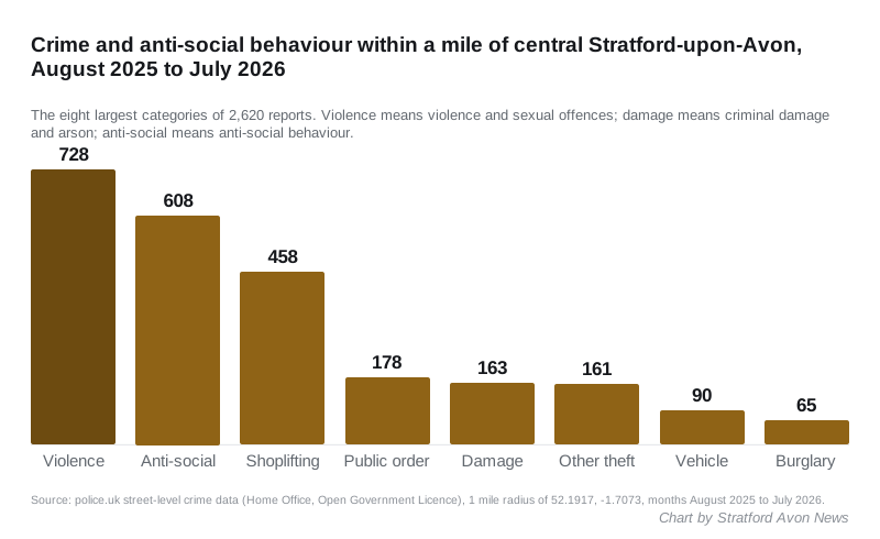
2,620 crimes were logged within a mile of central Stratford in the year to July. Violence rose 8% and vehicle crime fell 31%. Where, and what changed.
Police recorded 2,620 crimes and anti-social behaviour reports within a mile of central Stratford-upon-Avon in the 12 months to July 2026. That is 53 fewer than the year before, a fall of 2%. But the overall figure hides two sharp moves in opposite directions.
Violence and sexual offences rose 8%, from 672 to 728. Vehicle crime fell 31%, from 131 to 90.
These figures come from the Home Office’s street-level data on police.uk, which Warwickshire Police supplies every month. We compared August 2025 to July 2026 with August 2024 to July 2025. July 2026 is the latest month published.
What changed, type by type
| Type | Year to July 2025 | Year to July 2026 | Change |
|---|---|---|---|
| Violence and sexual offences | 672 | 728 | +56 (+8%) |
| Anti-social behaviour | 619 | 608 | -11 (-2%) |
| Shoplifting | 468 | 458 | -10 (-2%) |
| Public order | 204 | 178 | -26 (-13%) |
| Criminal damage and arson | 148 | 163 | +15 (+10%) |
| Other theft | 161 | 161 | no change |
| Vehicle crime | 131 | 90 | -41 (-31%) |
| Burglary | 70 | 65 | -5 (-7%) |
| Drugs | 49 | 42 | -7 (-14%) |
| Other crime | 47 | 45 | -2 (-4%) |
| Possession of weapons | 32 | 29 | -3 (-9%) |
| Bicycle theft | 28 | 15 | -13 (-46%) |
| Robbery | 17 | 27 | +10 (+59%) |
| Theft from the person | 27 | 11 | -16 (-59%) |
| All types | 2,673 | 2,620 | -53 (-2%) |
The last four rows are small numbers. A handful of reports either way moves the percentage a long way, so treat those changes with care.
Where it happens
Police.uk places each report at the nearest street or landmark, not the exact address, and some landmarks are given only a generic label. Over the 12 months to July 2026, the busiest locations were:
- a location police.uk labels “parking area”: 258 reports, 68 of them violence
- a location labelled “shopping area”: 190 reports, 139 of them shoplifting
- Regal Road, by the Maybird shopping park: 172 reports, 140 of them shoplifting
- a location labelled “theatre/concert hall”: 138 reports, 56 of them violence
Among named streets, Sheep Street had the most violence and sexual offences, with 30. John Street had 25 and Ely Street 23.
Regal Road also logged five of the 27 robberies, more than anywhere else. We reported on the CCTV arrests at the Maybird centre earlier this month.
Month by month
July 2026 was quieter than July 2025, with 237 reports against 263. The busiest month in the latest year was May 2026, with 264. The quietest was December 2025, with 180.
Violence and sexual offences peaked in March 2026 at 74 reports. Shoplifting also peaked that month, at 52.
What it means for you
The town centre is not getting worse overall. Total reports are down slightly, and car crime has fallen by almost a third. If you park in town, that is the clearest good news in the data.
Violence is the one to watch. It is the largest category and it grew. The biggest clusters are logged at the “parking area” and “theatre/concert hall” locations, and on Sheep Street, John Street and Ely Street. The category also includes offences without injury, stalking and harassment, so it is broad.
Shoplifting is steady but high. At 458 reports, it averages more than one a day, and more than half of it is logged at Regal Road and the “shopping area” location.
To see the figures for your own street, use the postcode search on police.uk. To report a crime, call 101, or 999 in an emergency. You can also report online through Warwickshire Police.
About these figures
The data counts crimes recorded by the police, not crimes committed. Changes can reflect how many people report, and how police record, as well as how much crime there is. The one-mile circle is centred on the town centre, at latitude 52.1917 and longitude -1.7073, and takes in the shopping streets, the riverside and the Maybird. Anti-social behaviour is not a crime category in law but police.uk publishes it alongside the crime figures, so we have included it.
Have your say