
Alcester's revised neighbourhood plan protects eight more green spaces, 19 in all, and sets a 10% biodiversity floor. Comments close 5pm on Friday 23 October.
Eight more pieces of open ground in Alcester would be protected from development under the town’s revised neighbourhood plan, which went out to six-week public consultation on Thursday 10 September. Comments close at 5pm on Friday 23 October 2026.
That takes the number of Local Green Spaces named in the plan to 19. The designation is not decorative. Under the plan’s Policy NE3, development that would harm the openness or special character of one “will not be supported unless there are very special circumstances which outweigh the harm”.
Six of the eight were left out of the version adopted in 2021 by mistake, and are now corrected. The other two are public open spaces created by a large housing development that has been built out since.
The 19 protected spaces
| Parks and recreation | Green space and allotments |
|---|---|
| Westbury Park | Arrow Valley corridor |
| Jubilee Fields | Alcester Town Cemetery |
| St Mary's Park, Kinwarton | Whitehall Farm Green Space |
| Bleachfield Street Play Area | Land at Eclipse Road |
| Collins Way Play Area | Land adjoining old Stratford Road |
| Moorfields Park | Bleachfield Street Allotments North and South |
| Gas House Lane Recreation Ground (Centenary Field) | School Road Allotments |
| Alcester Park Green Space | Allimore Lane Allotments |
| The Bowling Green | Alcester Park Allotments |
What else the review changes
The plan is a rewrite of the one Stratford-on-Avon District Council formally made on 12 July 2021, not a new document. Alcester Town Council told the district in September 2025 that it wanted to update it, and a volunteer steering group had been working on it since January 2024.
The town council’s own modification statement, submitted with the plan, sets out what has changed. The substantive points:
- The plan period runs to 2035, extended from the made version
- Development must deliver at least 10% biodiversity net gain, unless it is exempt, with more encouraged
- New developments are expected to achieve Secured by Design Silver Level certification, or the developer must explain why not, and to provide street furniture such as litter and dog bins, benches and noticeboards
- Small sites are encouraged for affordable housing, after the 2023 housing needs survey found supply short and sites limited
- A new project on natural flood management, because, as the statement puts it, Alcester has “two rivers running through the centre of the town and flooding is an ongoing significant risk”
- Two policies were deleted on the grounds that the issues are now covered by Building Regulations or by higher level planning policy
The town council says the changes do not add any new policies and do not change the nature of the plan.
Why the plan asks for bungalows
One policy carried over from 2021 is unusual enough to be worth restating. Policy HBE4 says developments of 10 or more homes inside the built-up area boundary should include at least 10% bungalows, specialist accommodation aside.
The plan’s justification is the town’s age profile, and the review updates it with 2021 Census figures.
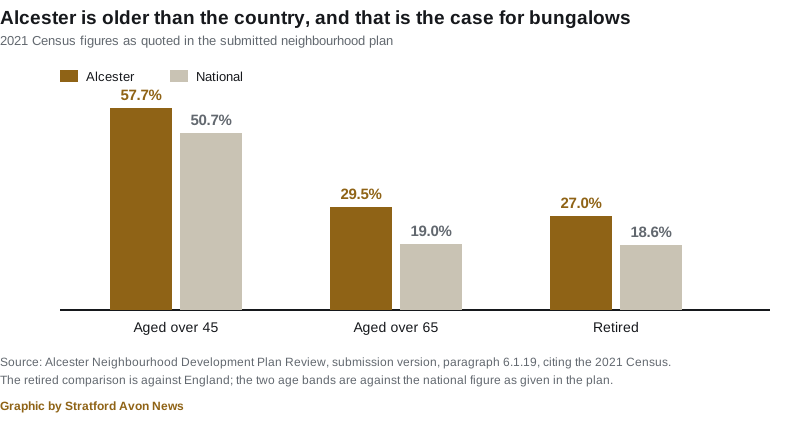
A 2017 housing needs survey for the town council had already identified a need for 17 bungalows.
Where Alcester stands on housing
The plan is blunt about how little room the town has. Green Belt, the conservation area, the river network and the scheduled monument sites leave “very little opportunity to develop in Alcester other than by infill within the Built Up Area Boundary”.
The two big allocations, ALC1 for up to 190 homes and ALC2 for up to 160, both between Allimore Lane and Birmingham Road, were granted on appeal in 2014 and are being built out.
On numbers, the district’s Core Strategy set an indicative target of about 530 homes for the Alcester area including Kinwarton over the plan period. Permissions and commitments already stand at 580, of which 119 are in Kinwarton.
The plan also records that average house prices in the B49 postcode are £380,000, which it puts at 41% above the national average, and that 12.8% of homes are privately rented. Our own district-wide house price tracker covers how that compares with the rest of the area.
What it means for you
If you live, work or run a business in Alcester or Kinwarton, this is the document that will be used to decide planning applications in the town once it is adopted. Neighbourhood plans form part of the statutory development plan, so they carry legal weight alongside district and national policy.
- The consultation closes at 5pm on Friday 23 October 2026. There is no extension mechanism.
- Read it online at stratford.gov.uk/neighbourhoodplans, or on paper at the district council’s offices in Church Street, Stratford, at Alcester Library or at Stratford-upon-Avon Library during opening hours.
- Respond using the online form at stratford.gov.uk/alcesternp, by emailing a completed form to planning.policy@stratford-dc.gov.uk, or by post to Planning Policy, Stratford-on-Avon District Council, Elizabeth House, Church Street, Stratford-upon-Avon CV37 6HX.
- What happens next. An independent examiner is appointed, considers the representations, and reports. Only then does the plan go to the district council to be made.
Our planning news page tracks the other plan that will shape the district, the South Warwickshire Local Plan, which is a separate document on a separate timetable.
Sources
- Alcester Neighbourhood Development Plan Review, Regulation 16 Consultation, report to Stratford-on-Avon District Council Cabinet, 7 September 2026, for the plan’s history, the 12 July 2021 adoption date, the submission on 24 April 2026 and the eight added Local Green Spaces.
- Submission version of the Alcester Neighbourhood Development Plan Review, for Policy NE3 and the list of 19 Local Green Spaces, Policy NE2 and the 10% biodiversity net gain, Policy HBE4 and the bungalow requirement, Policy HBE7 and Secured by Design, the census figures, the ALC1 and ALC2 allocations, the 530 and 580 housing figures and the £380,000 average price.
- Appendix 7, Modification Proposal Statement, March 2026, for what the review changes and the town council’s reasons.
- Have your say on the revised Alcester Neighbourhood Development Plan, Stratford-on-Avon District Council, 9 September 2026, for the consultation dates, the places to read it and how to respond.
Have your say